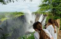
Zambia is one of the most stable and strife free countries in Africa. There has never been a war here and the 73 tribes live in relative peace and harmony. The Wildlife is superb and some of the finest Safaris on offer are available from our fine lodges. Blessed with 7 waterfalls including the spectacular Victoria Falls, Zambia offers holidays filled with adventure and scenic beauty.
Capital: Lusaka
Languages: English is the official language, along with Bemba, Nyanja, Lozi, Tonga, Luvale, Lunda, and Kaonde.
Best time to visit: June to November in the dry season.
Currency: Zambian Kwacha
Zambia Attractions
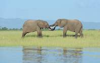
Apart from the most spectacular views of the magnificent Victoria Falls, Zambia has some of Africa's finest Game Reserves in the world. For high action adrenaline thrills and off-the-beaten track adventures: rafting, kayaking, canoeing trails, 4x4 routes. houseboating, horseback trails, scuba diving, bungi jumping, microlighting and some of Africa's best fishing spots - you will find Zambia unbeatable.
Geography
Zambia takes its name from the Zambezi River, which rises in the north west corner of the country and forms its southern boundary. It's neighbours are: Congo DR to the north and north west, Tanzania to the north east, Malawi to the East, Mozambique to the south east, Zimbabwe to the south, Botswana and Namibia to the South west and Angola to the West.
Zambia's 464 937 square kilometres makes it a large country about the size of France, the Netherlands, Belgium and Switzerland combined. It consists for the most part of a high plateau, with an average height of between 1060 and 1363 metres (3477.6 - 4471.7 feet) above sea level. Isolated mountain ridges rise to more than 6000 ft (1828.8 metres) with an occasional peak above 7000 ft (2133.6 metres) on the eastern border, called Nyika Plateau.
Over most of the country the surface tends to be flat, broken by small hills, the result of countless ages of undisturbed erosion of the underlying crystalline rocks. These rocks contain the bulk of the country's wealth in the form of minerals and the 90 mile long corridor known as the Copperbelt, along the north-western part of the country, is the mainstay of the economy.
The level of the land falls southward from the Congo Democratic Republic / Zambezi divide in the north towards the Zambezi depression in the South. The plateau is broken by the huge valleys of the Upper Zambezi and its major tributaries, of which the Kafue and Luangwa rivers are the largest. One result of the plateau formation of Africa generally is the swift discharge of water towards the coast and the interruption of the rivers by waterfalls and rapids.
This has made them of little value for transport over their length, but very suitable for hydroelectric schemes and white water rafting adventures. With the exception of the Northern and Luapula provinces which are part of the Congo DR basin, Zambia lies on the watershed between the Congo DR and Zambezi River systems.
The 3 great natural lakes of the country, Bangweulu, Mweru and the southern end of Lake Tanganyika are all in the north and are part of the headwaters of the Zaire River. Lake Tanganyika is the second deepest natural lake in the world.
Lake Bangweulu, which with its swamps covers an area of about 3800 square miles, is drained by the Luapula River. This river starts flowing south, then turns west and northwards to pass through Lake Mweru on its way to DRC. Along the southern border of the country stretches Lake Kariba, the largest man made lake in Africa and the second largest in the world. It is about 280kms (173.9 miles) long and 40kms (24.8 miles) across at its widest point.
Climate of Zambia
The general height of the land gives Zambia a more pleasant climate than that experienced in most tropical countries. There are 3 seasons: cool and dry from May to August, hot and dry from September to November, warm and wet from December to April. Only in the Valleys of the Zambezi and Luangwa is there excessive heat, particularly in October and, in the wet season, a high humidity. In the warm wet season, frequent heavy showers and thunderstorms occur, followed by spells of bright sunshine. Plants grow profusely and rivers and streams fill up almost overnight.
During the cool dry season, night frosts may occur in places sheltered from the wind. The countryside dries up gradually and grass fires, fanned by high winds are a feature of this time of the year. In depressions, radiation occurs on cloudless nights. Temperatures rise high during the hot, dry season but new leaves appear on the trees before the start of the rains and new grass brightens the countryside. The main growing period of woody vegetation is between August and November.
In the cool season the prevailing wind, dry south easterlies come from the southern hemisphere belt of high pressure. Invasions of cold air from the south-east bring cloudy to overcast conditions. During the hot season maximum temperatures may range from 27 C (80.6 F) to 35 C (95 F).
Zambia's vegetation is of the savanna type and over half the country is covered by trees, varying from the more open conditions in the drier south to tall dense woodlands in the north and north-west. These woodlands contain only hardwoods. The trees are bare for a brief period only and the spring leaves appear before the start of the rains. Grass fires spread rapidly in the dry season but new blades of grass soon push through the blackened earth.
Zambia's climate makes possible the cultivation of a wide range of crops; maize, tobacco, cotton, rice, wheat and groundnuts. All kinds of vegetables can be grown together with Citrus Fruit, Bananas, Pineapples, Mangoes, Avocados and even Grapes. Lichis are also a high potential export crop. Tea and coffee are also grown successfully in fact the coffee produced is of a very high quality. Sugar cane is grown both by villagers and commercially.
The People of Zambia

Zambia has over 73 different tribes, with a population of just about 10 million people, most of whom live in and around the urban centres. The population growth however, at 3.7 % p/a is among the highest in the world. In the cities, especially Lusaka, where there is massive unemployment and poverty, the informal sector has been allowed to multiply.
There is a growing number of thieves, pickpockets and beggars, but if you don't walk around with anything obviously stealable, it's quite safe and most will be more than willing to chat or give directions. For the most part Zambians are very friendly people.
There is no predominant ethnic culture and Zambians are fast becoming westernised. There is however, an attempt to maintain traditional customs with the revival of tribal ceremonies amongst the various tribes in different parts of the country. If any of these are taking place during your visit, they're well worth attending.
 Got a bit of the pioneer in you? Looking for a friendly welcome and a superb safari off the beaten track? Here are the top reasons to go on ...
 Zambia Safari Tours and safari lodges offer great appeal for those who want to experience the real Africa. The wilderness and rugged beauty ...